Hiking the Rakitnica canyon from Umoljani
How long does the Rakitnica canyon trek take and do I need a guide?
Reckon on half a day for the accessible upper stretch from Umoljani, a full day for a proper canyon crossing to Lukomir. Sections are unmarked and cross loose scree above the river, so a local guide or an organised group is the sensible choice rather than a comfort option.
Why Rakitnica is a different hike from Lukomir
Most day-trippers who make it up to the Bjelašnica plateau are heading for Lukomir, the highest permanently inhabited village in Bosnia and Herzegovina, and its viewpoint over the canyon below. That’s a genuinely good half-day out, covered in full in the Lukomir hike guide. Rakitnica is something else. It’s the canyon itself: a walk down into and along the gorge the Rakitnica river has cut through the plateau over millions of years, on paths that are narrow, exposed in places, and only partly marked. Standing on the rim at Lukomir and walking inside the canyon are two different days, and this page is about the second one.
The Rakitnica canyon runs for roughly 25 kilometres, cutting a channel up to 700 metres deep between Bjelašnica and the neighbouring Visočica massif. It’s one of the deepest and least developed canyons in the country, with no road access along its length and only a handful of footbridges and shepherd paths crossing it. That isolation is exactly why it stayed wild enough to look the way it does, and exactly why it deserves more caution than a marked national park trail.
Getting to the start: Umoljani
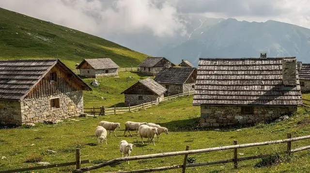
The trek starts at Umoljani, a small stone-roofed village on the Bjelašnica plateau about 30 kilometres from Sarajevo, roughly 45 minutes by car. Umoljani sits a little below Lukomir and slightly closer to Sarajevo, and it’s the more practical base for the canyon route because the marked trail down toward the gorge begins at its edge rather than requiring the longer approach from Lukomir first.
There’s no public transport to Umoljani. Most visitors drive, join an organised hike, or arrange a taxi from Sarajevo for the day, agreeing a fixed return price before setting off since there’s no meter service this far out. Parking is informal at the village entrance; a few households offer rooms and simple meals, and asking around for the current state of the trail is worth doing before you leave, since conditions on unmarked stretches change from one week to the next.
If you’d rather not organise the driving and route-finding yourself, a guided option that covers this stretch of the plateau, including the drive up and a village stop, takes the logistics off your hands:
a guided day hike to Lukomir and the Bjelašnica plateau from SarajevoThe route and what to expect
From Umoljani, a marked path descends through pasture and scrubby beech woodland toward the canyon rim. This first stretch, roughly 45 minutes to an hour of descent, is well trodden and reasonably easy to follow. It ends at an overlook where the canyon opens up properly: sheer grey rock walls, the river a thin green line far below, and Visočica’s ridge on the far side.
That overlook is a sensible turnaround point for a half-day outing, and it’s where most casual walkers stop. Continuing past it changes the character of the hike considerably. The path narrows, drops steeply over loose scree, and in several places follows ledges cut into the rock face with a real drop below. Waymarking thins out here to occasional red-and-white paint marks on rocks, spaced unevenly, and in a few stretches there is no marking at all — you’re following a visible line worn by shepherds and previous hikers rather than a signed trail.
The canyon floor itself is reached after a descent of 300 to 400 vertical metres from the rim, depending on where you start down. Down at the river, the walking eases: a rough path follows the Rakitnica along shingle banks and through overhanging rock, crossing the water at a couple of points on stepping stones or, seasonally, a simple footbridge. It’s a genuinely beautiful stretch, cold clear water, sheer walls on both sides, and almost total quiet.
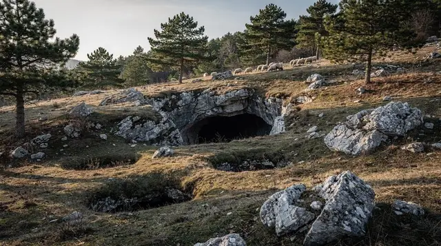
Ordinance dating from the 1984 Winter Olympics era still marks some of the plateau’s old shepherd paths, and a handful of stone huts (katuni) survive along the rim, used seasonally by herders bringing sheep up from the valley in summer. None of this is set up for visitors — there’s no café, no toilet, no signal-based safety net — so treat the whole route as genuine backcountry, not a park trail with a wilder view.
Two ways to do it: half-day loop or full traverse
The half-day version goes from Umoljani down to the main overlook and back the same way, roughly three to four hours round trip including a stop to take it in. This suits anyone who wants the canyon’s scale without the scree and exposure of the lower sections, and it’s the version to choose if the weather is uncertain or if anyone in the group isn’t confident on loose rock.
The full traverse continues down to the river, follows it for a stretch, and climbs the far side up into Lukomir, finishing at a completely different village from the one you started in. This is a six-to-eight-hour day, properly technical in the descent and ascent, and it requires either a car left at Lukomir beforehand, a pre-arranged pick-up there, or a guide who handles that logistics for you. It is not a there-and-back walk you can improvise on the day; deciding the exit point has to happen before you go down, not once you’re at the bottom of the gorge.
| Option | Distance / time | Terrain | Best for |
|---|---|---|---|
| Rim overlook loop | ~5 km, 3–4 hours | Marked path, one steep but short descent | Most visitors, uncertain weather |
| Full canyon traverse | ~14–16 km, 6–8 hours | Unmarked scree, river crossings, steep climb out | Fit, experienced hikers, guided or with prior route knowledge |
Why a guide is the sensible call, not just a precaution
This isn’t the standard travel-guide reflex of recommending a guide for everything. The unmarked sections of the Rakitnica genuinely change from season to season — a path that was clear in July can be washed out by an autumn storm, and the scree slopes above the river are unforgiving if wet or icy. Phone signal disappears for most of the descent and along the river, so a fall or a wrong turn on the lower sections isn’t something you can simply call for help about. Local guides based in Umoljani and Lukomir walk this canyon regularly and know which crossings are currently passable, which makes the difference between a memorable day and a genuinely risky one.
If you’d rather not commit to organising a guide specifically for the canyon, joining a broader Bjelašnica plateau hike and asking your guide about extending into the gorge, or simply doing the shorter rim-overlook version independently, are both reasonable middle grounds.
The landmine question, briefly
Bosnia’s rural areas, this plateau included, still carry areas of suspected mine contamination away from marked paths and villages, a legacy of the 1992–1995 war. The routes described here, along established trails between Umoljani, the canyon rim, and Lukomir, are walked regularly and considered safe. The rule that matters is simple: stay on the visible path, don’t cut across open pasture or old fighting positions to shortcut a bend, and if a guide or local tells you a stretch is off-limits, treat that as final. The full picture is in the landmine safety guide for hiking in Bosnia, worth reading once before any off-trail walking in the country, not just here.
Season, weather and what to pack
The canyon is realistically walkable from late May to early October. Snow can sit on the plateau into May in a heavy year, and the scree sections become genuinely dangerous with any ice or fresh snow, so shoulder-season attempts depend entirely on that year’s conditions — ask in Umoljani before setting out rather than guessing. July and August bring the most reliable weather but also the most heat on the exposed rim sections; starting early avoids the worst of the midday sun on the scree.
Bring proper hiking boots with ankle support — trainers are a genuine liability on the scree — trekking poles if you use them, at least 1.5 litres of water since there’s no reliable source until the river, sun protection for the exposed rim stretch, and a headtorch as a precaution against a longer-than-planned day. A paper map or a downloaded GPX track is worth having given how unreliable phone signal is in the gorge itself.
How the day unfolds, step by step
Start early and treat the first hour as a calibration. The pasture and beech woodland below Umoljani give you a fair read on how the group moves, how the boots feel and how the weather is behaving. If anyone is already struggling on the easy descent, the overlook is your answer: enjoy it, eat something, and walk back up. Nobody who turns around at the rim has had a worse day than someone who pushed on and regretted it.
Past the overlook, slow down rather than speed up. Loose scree rewards short steps, planted poles and a gap between walkers so that nobody is underneath a dislodged stone. Stop at the paint marks, look ahead for the next one before moving, and if you cannot find it, go back to the last one you saw instead of improvising a line. Shepherd tracks look convincing and often lead nowhere useful.
At the river, take a proper break. This is the one place on the route where the pace drops and the canyon feels enclosed rather than exposed, and it is also the place to reassess. Check how much water is left, how tired the group is, and how long the climb out will take. The ascent toward Lukomir is the hard part of the day, and it arrives when legs are already tired.
Photography, pace and respect for the plateau
The light in the canyon changes quickly. Early morning shadows fill the gorge while the rim is already bright, and by midday the walls flatten out in the glare. If photographs matter to you, the overlook in the morning is the strongest frame; the river section is better when the sun has climbed enough to reach the water. Keep the camera away from your hands on the ledges, and never step back for a better angle near an edge.
The plateau is a working landscape. Shepherds use the same paths, animals graze the pastures and the katuni belong to the families who use them, so close any gate you open, keep your distance from livestock and ask before photographing people or their property. A greeting goes a long way in the villages, and the guesthouse families are usually generous with advice if you ask about the state of the path. For wider habits worth knowing before you go, see the guide to visiting Sarajevo respectfully, and for the practical side of getting around the country, the driving in Bosnia guide and the car rental guide cover the road up to the plateau.
Who should choose which version
The rim overlook suits families with confident older children, casual walkers and anyone using the canyon as one stop in a wider Bjelašnica day. The full traverse is for people who already enjoy long days on rough ground, are comfortable with heights and can accept that the way out is forward, not back. Anyone who needs a handrail, dislikes exposure or hikes only occasionally should enjoy the canyon from the rim and leave the descent alone. If you are unsure which group you belong to, the hiking around Sarajevo guide lists gentler routes that build the same fitness with fewer consequences, and the Lukomir day trip is the easy way to see the same view.
Where to stay and what else to combine it with
Umoljani and Lukomir both have simple guesthouse rooms and home-cooked meals, and staying a night in one of them turns this from a rushed day trip into a proper two-day outing on the plateau, with time to also see Umoljani itself and the wider Rakitnica canyon rim without racing the daylight. For those based in Sarajevo without a car, the day trips without a car guide covers how to reach the plateau without driving yourself.
If the canyon isn’t feasible on your dates, whether from weather, fitness, or simply time, the wider Bjelašnica and Umoljani day trip covers gentler ways to see the same plateau, and the general hiking around Sarajevo guide rounds up other routes closer to the city. Bosnia’s most complete wilderness, Sutjeska National Park and the Perućica primeval forest, is a longer trip but a natural next step for anyone who found this canyon underwhelming in scale — Perućica’s old-growth forest is protected with an even stricter access rule, guide only, no exceptions.
Some visitors prefer to swap a demanding hiking day for a different kind of adventure entirely, particularly if weather rules the canyon out. Options further afield include: a quad tour to see the wild horses near Livno and, further south toward Herzegovina, a half-day at the Kravica waterfalls and Počitelj which needs no technical footwear at all and runs regardless of scree conditions on the plateau.
Practical notes before you go
Mobile signal is patchy from the canyon rim and effectively absent along the river — tell someone your planned route and expected return time before setting off, standard practice for any backcountry walk here. There are no facilities once you leave Umoljani: no toilets, no rubbish bins, no shop. Pack out everything you bring in.
Costs on this route are minimal if you’re independent — no entrance fee, no infrastructure to pay for — which means the real cost is the guide or transport, not a ticket. A half-day guided outing from Sarajevo covering the plateau typically runs alongside the standard Lukomir hikes; ask specifically whether the canyon descent is included, since not every plateau tour goes past the rim overlook.
Finally, this is not a hike to treat as a warm-up or an afterthought squeezed in after Lukomir village. Build a full day around it, check conditions locally before descending past the rim, and turn back at the overlook without hesitation if the weather turns or the group isn’t comfortable on loose rock. The canyon has been there for millions of years; it will still be there on a better day.
Hiking & nature tours on GetYourGuide
Verified deep-linked GetYourGuide tours. Book through these links and we earn a small commission at no cost to you.
GetYourGuide does not provide a product photo for this activity — the image shows the meeting point, photographed by us.