Bjelašnica and Umoljani: a day trip from Sarajevo
Can you visit Bjelašnica and Umoljani in one day from Sarajevo?
Yes. Bjelašnica is about 30 km and 45 minutes from Sarajevo, and Umoljani is a further 20 minutes on a rougher road. Most visitors combine the two with a short, well-marked walk from Umoljani towards the Rakitnica canyon rim, and are back in Sarajevo by early evening.
Bjelašnica and Umoljani sit on the same upland shoulder above Sarajevo, roughly half an hour apart by road, and they answer two different questions. Bjelašnica is where the men’s downhill ran at the 1984 Winter Olympics and where Sarajevo goes to ski today. Umoljani is a working stone hamlet on the edge of the Rakitnica canyon, the usual starting point for walks towards medieval tombstones and high pasture, and the place people mean to visit when they actually mean Lukomir, the higher and more remote village further along the same road.
What Bjelašnica and Umoljani actually offer
Put simply: Olympic infrastructure and long views at Bjelašnica, and a lived-in mountain village with a short, genuinely rewarding walk at Umoljani. Neither is a single unmissable sight — the appeal is spending three or four hours outdoors, in air that is usually noticeably cleaner than Sarajevo’s, with distances short enough to still have lunch back in the city if you want it.
Bjelašnica: from Olympic downhill to modest resort
Bjelašnica hosted the men’s alpine skiing events of the 1984 Winter Olympics, and the mountain still carries that history plainly: the old finish area, weathered lift infrastructure, and a resort that has never grown much beyond what the Games left behind. That is not a criticism. It means Bjelašnica in summer is quiet, cheap, and largely used by locals rather than tour buses.
The drive from Sarajevo is about 30 km and 45 minutes, via Hrasnica and Ilidža. The road climbs steadily and is paved the whole way to the ski settlement, which sits at around 1,230 metres. From there, a network of gravel tracks and marked paths climbs further towards the ridge, past clusters of restored stone shepherd huts known locally as katuni — round, stone-roofed structures once used for summer grazing, now mostly maintained as a heritage feature rather than working huts.
In winter this becomes one of two main ski areas near Sarajevo, alongside Jahorina on the other side of the valley — worth comparing directly if skiing is the plan rather than a summer walk. For the Olympic story specifically, and what remains of the 1984 venues across Bjelašnica, Igman, and Trebević, see the fuller background on Sarajevo’s Olympic legacy.
For anyone visiting purely to walk, the summer routes on Bjelašnica are covered in more depth separately, including which sections need no special preparation and which start to require real hiking gear.
If the Olympic story is what draws you, the 1984 Olympics legacy guide explains what the Games left on these slopes, and the Bjelašnica summer guide goes through the walking options in more detail. For the neighbouring mountain, which pairs naturally with Bjelašnica, see Igman and its visiting guide.
a guided day out that covers both Igman and Bjelašnica before continuing to Umoljani village is the most efficient way to see all three without driving yourself, and it removes the question of where exactly to park and which gravel track to take.
Umoljani: the last stone village before the wild canyon
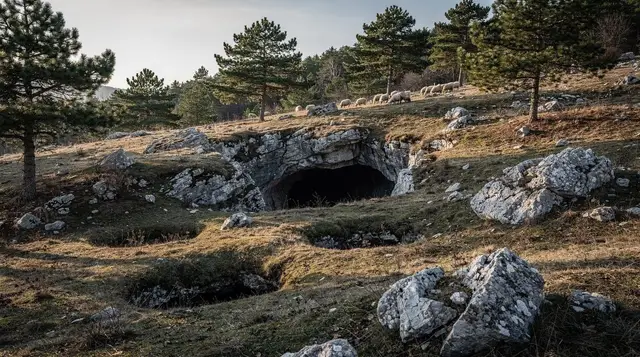
Twenty minutes beyond Bjelašnica’s ski settlement, on a road that turns from tarmac to a maintained but unpaved surface, Umoljani sits at around 1,500 metres on the edge of the Rakitnica canyon. It is a genuine village, not a reconstruction: stone houses with wooden shingle or tin roofs, a scatter of guesthouses, grazing sheep, and a handful of families who still live there year-round rather than only in summer.
Umoljani is also the place most visitors confuse with Lukomir, and the distinction is worth being precise about. Umoljani has road access all year, several places to eat and sleep, and sits at a lower, gentler position on the plateau. Lukomir, the country’s highest permanently inhabited village at roughly 1,469 metres, lies a further stretch of rough, unsurfaced road beyond Umoljani, cut off by snow for part of the winter, and is usually treated as its own, longer excursion rather than an add-on to a Bjelašnica day. If Lukomir specifically is the goal, plan for it separately.
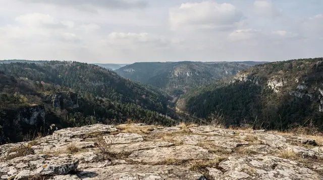
What Umoljani gives you on a half-day visit is straightforward: a walk out from the village towards the canyon rim, passing a necropolis of stećci — the carved medieval tombstones found across Bosnia and Herzegovina in larger numbers than almost anywhere else in the region — and views down into the Rakitnica canyon itself, a narrow limestone gorge that is one of the more dramatic landscapes within easy reach of Sarajevo.
The one rule that matters more than any view
This needs saying plainly, and it applies to Umoljani, the Rakitnica canyon, and this whole upland region generally: parts of it sat on or near front lines during the 1992 to 1995 war, and demining of Bosnia and Herzegovina’s countryside is not finished. Antipersonnel mines are still suspected across sections of rural land, including in areas that look, and mostly are, completely safe to walk.
The rule is simple and non-negotiable: stay on marked trails, established roads, and areas that are visibly and regularly used by locals and other walkers. Do not cut across an open field to save ten minutes, do not follow an animal track off the main path out of curiosity, and take seriously any yellow or red warning sign or tape — they mark a real hazard, not bureaucratic caution. For anything beyond the well-known route from Umoljani to the stećci and the canyon rim, or for descending into the Rakitnica canyon itself, hire a local guide. This is covered in more detail in a dedicated guide to hiking safety and mine awareness across Bosnia, and it is worth reading before any walk in this region, not just this one.
The landmine safety guide for hiking in Bosnia is the place to start, and the Bosnian war context for visitors explains why the countryside still carries this risk.
None of this should put you off the standard route — it is walked by hundreds of people every summer weekend without incident, precisely because it stays on the known path.
Walking from Umoljani: what the standard route looks like
The usual walk starts at the edge of the village, follows a clear track past grazing land, and reaches the stećci necropolis within twenty to thirty minutes. From there, a further hour or so of gentle uphill and level walking brings you to one of several viewpoints over the Rakitnica canyon, where the gorge drops away sharply below the plateau. Return the same way, and the round trip is comfortably two to three hours for most walkers, with no technical sections, scrambling, or exposure on the standard path.
Good walking boots, water, a hat in summer, and a layer for wind on the ridge are all that most visitors need. This is not a route that requires specialist gear, provided you keep to it — which is, again, the entire point of the mine-safety rule above.
For a longer walk that follows the canyon rim further, or descends towards the river itself, the terrain and route options are set out separately, and this is exactly the territory where a local guide earns their fee rather than being an optional extra.
The Rakitnica canyon trek guide and the Lukomir hike guide cover those longer options, and hiking around Sarajevo puts them next to the easier walks nearby.
a guided highlands walk that includes a proper lunch stop is a good option for anyone who would rather not navigate the stećci trail alone, particularly on a first visit or outside peak summer weekends when the path is quieter and less obviously marked underfoot.
How to combine both in a single day
The efficient order is Bjelašnica first, then Umoljani. Leave Sarajevo by mid-morning, spend an hour or so at Bjelašnica’s Olympic area and the nearby katuni, then continue the twenty minutes to Umoljani for the walk to the stećci and canyon viewpoints, allowing two to three hours there. Lunch works well either in Umoljani itself, at one of the small guesthouses serving home-style Bosnian food, or back at Bjelašnica on the return leg. Most visitors are back in Sarajevo by early evening, which leaves the option of dinner in Baščaršija rather than eating on the road.
Driving yourself is straightforward in dry conditions with an ordinary car; the tarmac ends a little beyond Bjelašnica’s ski settlement, and the remaining stretch to Umoljani is a well-maintained gravel and packed-earth road rather than anything requiring four-wheel drive. In winter or after heavy rain, conditions can change quickly, and a guided minibus removes that variable entirely. Notes on renting a car in Sarajevo and on driving conditions generally in Bosnia are covered elsewhere if self-driving is the plan.
If you drive, read the car rental guide for Sarajevo and the notes on driving in Bosnia before setting off. Those who would rather skip the wheel can compare guided tours with independent travel.
a day tour that pairs Umoljani with Lukomir is worth considering if the higher village is genuinely the priority and Bjelašnica’s Olympic sites are secondary — it covers more ground than the Bjelašnica-and-Umoljani combination above, at the cost of a longer day.
Bjelašnica, Umoljani, and Lukomir compared
| Bjelašnica | Umoljani | Lukomir | |
|---|---|---|---|
| Distance from Sarajevo | ~30 km / 45 min | ~50 km / ~1 h | ~50 km / 1 h 30 (final stretch unpaved) |
| Altitude | ~1,230 m (resort base) | ~1,500 m | ~1,469 m |
| Road access | Paved throughout | Paved then gravel | Rough, seasonal |
| Character | Former Olympic resort | Working stone village | Country’s highest inhabited village |
| Typical visit | 1–2 hours | Half-day, with the walk | Full day |
| Best paired with | Igman, Umoljani | Bjelašnica | A dedicated day, not tacked on |
Eating in Umoljani and Bjelašnica
Umoljani has a handful of small guesthouses that serve simple, home-style Bosnian food to non-guests as well: usually a soup, grilled or stewed meat, fresh bread, and honey or cheese produced on-site or nearby. Portions are generous and prices are modest, typically in the 12 to 20 KM range for a main dish. Bjelašnica’s resort has a few cafés and restaurants near the base, aimed mostly at skiers in winter and quiet but functional in summer. Neither location has the range of Sarajevo, so this is not the place for a long, planned meal — treat lunch here as part of the walk rather than a destination in itself.
When to go
Late spring through early autumn is the practical window for the walk from Umoljani: the path is dry, the stećci and viewpoints are fully accessible, and the road is at its most reliable. High summer weekends bring more visitors and can mean a busier trail near the village, though it rarely feels crowded by comparison with Sarajevo’s own sights. Winter closes the walking route in any meaningful sense — Bjelašnica becomes a ski destination instead, and Umoljani, while not entirely cut off, is a different and colder trip that suits skiing or snowshoeing rather than this walk.
Getting there without a car
There is no scheduled public bus to Umoljani, and taxis from Sarajevo for a round trip with waiting time are expensive over this distance and road surface. In practice, the realistic options without a car are a booked tour, a private transfer arranged in advance, or joining a local hiking group that organises transport as part of the outing — all covered in more general terms for day trips from Sarajevo that don’t rely on driving yourself.
The day trips without a car guide lists the options, and best day trips from Sarajevo shows how this outing compares with the alternatives. The Lukomir day trip guide is the next step if the higher village appeals.
a guided day trip to a different lake and mountain landscape south of Sarajevo is worth knowing about as an alternative if Bjelašnica and Umoljani are already booked or full on your dates — it covers similarly quiet, uncrowded terrain within a comparable driving distance.
Bjelašnica and Umoljani in a wider itinerary
Both places fit naturally into a nature-focused week based in Sarajevo, alongside Lukomir, the Rakitnica canyon, and the national parks further south. For a fuller week that strings these together with Sutjeska and the Una, a seven-day nature itinerary sets out a sensible order and pacing rather than trying to see everything from a single base in one long day.
The Bosnia nature week lays this out day by day, and the Sarajevo mountain huts guide is useful if you would rather stay overnight in the hills than drive back.
Frequently asked questions about Bjelašnica and Umoljani
How far is Bjelašnica from Sarajevo?
About 30 km, roughly 45 minutes by car via Hrasnica and Ilidža. There is no train or tram connection; a car, transfer, or organised tour is the practical option.
Is Umoljani the same as Lukomir?
No, and mixing them up is the most common mistake. Umoljani sits lower, around 1,500 metres, with year-round road access and several guesthouses. Lukomir, the country’s highest permanently inhabited village at roughly 1,469 metres, is a further unsurfaced stretch beyond Umoljani and is usually a separate, longer excursion.
Are there landmines near Bjelašnica and Umoljani?
Parts of this upland region were front lines during the 1992 to 1995 war, and demining is not complete everywhere. The absolute rule is to stay on marked trails and roads and within visibly used areas, respect any yellow or red warning signs, and hire a guide for anything beyond the known paths.
Do you need a car to get to Bjelašnica and Umoljani?
A car or a booked tour is the realistic answer. There is no scheduled public bus to Umoljani, and the last stretch of road is unpaved. Self-driving is possible with a normal car in dry weather, but a guided minibus removes the routefinding and the return-drive concern after a long day outdoors.
What can you see at Bjelašnica beyond the ski lifts?
The former 1984 Olympic downhill course, restored stone shepherd huts (katuni) on the upper slopes, and long views towards Igman and the Rakitnica canyon. In summer the resort itself is quiet; the appeal is the walking and the views rather than any single sight.
Is the walk from Umoljani difficult?
The standard route to the stećci and the canyon viewpoints is a moderate, well-trodden path of two to three hours return, with no technical sections. Good boots and water are enough for most visitors; anything further into the Rakitnica canyon needs a guide and more time.
What is a stećak and why are there so many near Umoljani?
A stećak is a medieval tombstone, often carved with geometric or figurative reliefs, dating roughly from the 12th to the 15th century. Bosnia and Herzegovina holds the largest concentration in the region, and the necropolis above Umoljani is one of the more accessible groups to see on foot.
Mountain excursions on GetYourGuide
Verified deep-linked GetYourGuide tours. Book through these links and we earn a small commission at no cost to you.
GetYourGuide does not provide a product photo for this activity — the image shows the meeting point, photographed by us.