Hiking around Sarajevo
What is the best hike near Sarajevo?
Trebevic is the easiest, ten minutes by cable car from the city and free to walk once you're up. For a proper day hike, Bjelasnica and Lukomir are the two most rewarding, both roughly 45 minutes to an hour and a half from Sarajevo by road, the last stretch to Lukomir on unpaved track.
Seven trailheads within day-trip range
Sarajevo sits in a valley with mountains on three sides, which means the city has more genuine hiking within an hour’s drive than almost any other capital in Europe. This page is a sorting tool, not a trail narrative: it lists the seven places people actually hike from Sarajevo, how far each one is, how long it takes to get there, and what kind of day it makes. For step-by-step routes, each entry links through to a dedicated guide.
None of this is extreme terrain. These are day hikes and half-day walks, reachable by taxi, tour transfer or, in a couple of cases, by public transport. The one genuine hazard in the wider countryside — landmines left over from the 1992-1995 war — gets one paragraph near the end, with a link to the full safety guide. It is not a reason to avoid these trails; it is a reason to stay on them.
Trebevic: the closest hike, reached by cable car
Trebevic is the mountain that overlooks the old town, and it’s the easiest of everything on this list. The Sarajevo cable car reopened in 2018 after 26 years out of service, running from Bistrik up to 1,164 metres in about nine minutes; a return ticket costs around 20 KM (roughly 10 euros). From the top station, marked paths run along the ridge, past picnic spots and viewpoints, to the abandoned 1984 Olympic bobsleigh track — now covered in graffiti and one of the most photographed spots in the city, reachable on foot in twenty to thirty minutes.
Trebevic works as a half day: cable car up, an hour or two of walking, cable car down, back in the city centre for lunch. It needs no special gear and no transport of your own. The full route options are in the Trebevic hiking guide; the bobsleigh track has its own visiting guide.
Bjelasnica and Jahorina: the 1984 Olympic mountains
Bjelasnica and Jahorina hosted the men’s and women’s alpine skiing at the 1984 Winter Olympics, and both run as hiking destinations for the other nine months of the year. Bjelasnica is about 30 kilometres and 45 minutes from Sarajevo by road; Jahorina is a similar distance and time, on the Republika Srpska side of the city. Both have mountain huts, marked summer trails, and chairlifts that often keep running in summer for walkers rather than skiers.
The going is proper mountain walking rather than a stroll — expect several hours out, sturdy shoes, and weather that turns faster than in the valley below. Neither needs a guide for the standard marked routes. Details, trailheads and hut information are in the Bjelasnica summer guide and the Jahorina summer guide.
a guided day hike up neighbouring Treskavica, with transport and lunch included is a reasonable option if you’d rather not sort out your own transfer to a trailhead this far out, and it covers terrain in the same range as Bjelasnica without you needing a car.
Skakavac: a 98-metre waterfall, twelve kilometres out
Skakavac is a 98-metre waterfall about twelve kilometres north of the city, inside a protected nature reserve. It’s the shortest proper forest hike on this list — figure two to three hours round trip once you’re at the trailhead, through beech woodland that stays cool even in the July and August heat that sits heavy in the valley. The waterfall is at its fullest with spring snowmelt; by late summer the flow thins to a trickle, but the walk itself still earns the trip.
There’s no public transport to the trailhead; a taxi or an organised hike is the practical way in. Route notes are in the Skakavac waterfall hike guide.
Vrelo Bosne: an easy walk, not a hike
Vrelo Bosne, the spring of the River Bosna, sits at the end of a 3.5-kilometre avenue of plane trees in Ilidza, about twelve kilometres from central Sarajevo — 20 to 25 minutes by tram and a short walk, or taxi. It is flat, shaded, and walkable in trainers; people do it on foot, by rented bike, or by horse-drawn carriage. It belongs on this page because visitors often ask whether it’s a hike, and it isn’t one — it’s the easiest outdoor half-day near the city, worth pairing with a coffee in Ilidza rather than treating as exercise. The Vrelo Bosne visiting guide covers the practical details.
Bijambare: caves and forest, thirty kilometres out
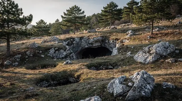
Bijambare is a set of show caves inside a protected forest reserve, about 30 kilometres from Sarajevo. One cave is lit and walkable without equipment, on a short guided loop; the surrounding reserve has marked forest trails if you want to extend the visit into a half-day walk rather than a quick stop. It’s a reasonable pairing with a morning in the city, and it doesn’t need serious hiking gear. The Bijambare caves visiting guide has opening hours and entry prices.
Lukomir and the Rakitnica canyon: the highest village in the country
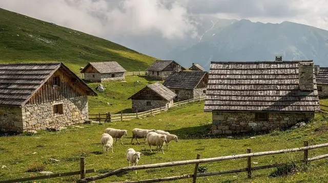
Lukomir, at around 1,469 metres, is the highest permanently inhabited village in Bosnia and Herzegovina — stone houses under shingle roofs, cut off by snow for part of the winter, with a handful of families still there in summer. It’s about 50 kilometres from Sarajevo, but the last stretch runs on unpaved mountain track, which is why it’s usually done by 4x4 rather than an ordinary rental car, and takes an hour to an hour and a half each way.
From Lukomir, marked paths drop into the Rakitnica canyon, a deep, little-visited gorge that’s one of the more serious hikes on this list — this is the one place here where hiring a local guide is a genuinely good idea rather than an optional extra, given the remoteness and the patchy waymarking beyond the main viewpoints. Nearby Umoljani makes a gentler base for the same high plateau if you want mountain scenery without committing to the canyon descent.
a full-day guided hike to Lukomir handles the 4x4 transport and the walking route in one booking, which solves the access problem outright. If you’d rather see the village without the hike itself, a private 4x4 safari out to the village covers the same ground at a slower, less strenuous pace. Route detail either way is in the Lukomir hike guide and the Rakitnica canyon trek guide; a lighter version aimed at a shorter visit is the Lukomir day trip guide, and the wider plateau is covered in the Bjelasnica and Umoljani day trip guide.
Further out again, the Sutjeska National Park area around Zelengora holds some of the most remote terrain within striking distance of Sarajevo, including the country’s oldest primary forest. a 4x4 day trip into the Zelengora mountains with a barbecue lunch is the practical way to see it without organising a multi-day trek.
Choosing between the seven
The simplest way to pick is to start from the kind of day you want rather than the name of the mountain. If you have only a morning, Trebevic and Vrelo Bosne are the two that fit without any planning: one gives you a ridge and a view over the old town, the other gives you shade and flat ground. If you have a full day and want to feel properly out of the city, Bjelasnica, Jahorina and Lukomir are the real mountain days. Skakavac and Bijambare sit in between, each a forest outing that fills a half day and asks little of your legs.
It also helps to be honest about fitness. Nothing here is technical, but the mountain days involve several hours on your feet, uneven ground and altitude that makes the same distance feel longer than it does at home. Travelling with someone who prefers cafés to ridgelines is easy to handle: Trebevic and Vrelo Bosne both give a walker and a non-walker something to do in the same place. If you are building a longer stay around these walks, the Sarajevo trip planning guide shows how to fit them around the city sights.
Getting to the trailheads without a car
Most of the trailheads here are outside the city, and that is the practical obstacle rather than the walking itself. A taxi is the flexible answer for Skakavac, Bijambare, Bjelasnica and Jahorina, and it is worth agreeing the return arrangement before you set off, because mobile signal and passing traffic are both unreliable once you are up a mountain road. The taxis in Sarajevo guide explains how to arrange a fare and a pick-up, and the day trips without a car guide covers the other options for reaching places outside the city.
For Lukomir and the high plateau, the unpaved track makes the decision for you: either a tour with 4x4 transport or a driver who knows the road. Whether to book a guided day or sort it out yourself is a question that comes up across Bosnia, and the guided tour versus independent travel guide sets out the trade-offs. As a rule of thumb, the closer to the city the trailhead is, the easier it is to go alone; the further into the mountains, the more a guide earns their fee.
What to bring and when to go
Weather on the mountains turns faster than in the valley, so a light waterproof layer and sturdy shoes belong in the bag even on a warm morning. Bring water and food for the whole outing, since the remote trails have no shops along the way. The Sarajevo packing list has the longer version, and the best time to visit Sarajevo guide helps you match the season to the walk: spring for the waterfall at its fullest, summer for cool forest and high plateaus, and the colder months for the ski side of the same mountains.
If you plan to stay up high rather than return the same day, the Sarajevo mountain huts guide is the place to start. A hut stop also works as a planned rest on a long day, a chance to sit down, eat and check the sky before you decide whether to continue or turn back. Turning back is a normal decision on a mountain, not a failure, and every trail on this page is better walked at a comfortable pace than rushed to hit a schedule.
Distances and durations at a glance
| Trail | Distance from Sarajevo | Typical time | How to get there |
|---|---|---|---|
| Trebevic | ~4 km to cable car base | 9 min by cable car, then 1-2 hrs walking | Cable car from Bistrik, ~20 KM return |
| Vrelo Bosne | ~12 km | 20-25 min, then a flat 1-2 hr walk | Tram to Ilidza, then walk or fiacre |
| Skakavac waterfall | ~12 km | 45 min drive, 2-3 hrs walk | Taxi or organised hike |
| Bjelasnica | ~30 km | 45 min drive, half to full day | Taxi, transfer or self-drive |
| Bijambare caves | ~30 km | 45 min drive, 2-3 hrs on site | Taxi or organised tour |
| Jahorina | ~30 km | 45 min drive, half to full day | Taxi, transfer or self-drive |
| Lukomir / Rakitnica canyon | ~50 km | 1-1.5 hrs, mostly on unpaved track | 4x4 tour or arranged taxi |
The one rule that matters: stay on marked paths
Every trail on this page is walked regularly and is safe to follow as marked. The single rule that applies across Bosnia and Herzegovina’s countryside, and that’s worth internalising before any hike beyond a city park, is this: never leave a marked path or a frequented area, and take a local guide for anything that isn’t a known, waymarked route.
Landmines from the 1992-1995 war are still suspected across parts of the countryside, and the marked trails around Sarajevo exist precisely because they’ve been cleared and are walked often. The full explanation, including how to read warning signs, is in the landmine safety guide for hiking in Bosnia — read it once, and it covers every trail on this page and beyond.
Questions about hiking near Sarajevo
Which hike near Sarajevo is best for a half day?
Trebevic, reached by cable car from Bistrik in about nine minutes. You can walk the ridge, see the abandoned 1984 bobsleigh track and be back in the city for lunch.
How do I get to Lukomir without a car?
There is no scheduled public transport to Lukomir. The realistic options are a day tour with 4x4 transport from Sarajevo, or a taxi arranged both ways, since the last stretch is unpaved mountain track.
Is Skakavac waterfall worth the trip in summer?
Yes, though the 98-metre drop is at its fullest in spring. In July and August the flow thins but the forest walk to reach it, about twelve kilometres north of the city, still holds up on its own.
Do I need a guide for the Rakitnica canyon?
For anything beyond the marked viewpoints near Lukomir and Umoljani, yes. The canyon is remote, the paths are not consistently waymarked, and mobile signal is patchy.
Are Bjelasnica and Jahorina worth visiting outside ski season?
Yes. Both were 1984 Winter Olympic venues and both run hiking trails and mountain huts through summer, with none of the lift queues or prices of ski season.
Is Vrelo Bosne a hike or a walk?
A walk, not a hike. It’s a flat 3.5-kilometre avenue of plane trees from Ilidza to the spring, done on foot, by bike or by horse-drawn carriage, with no elevation to speak of.
What about landmines when hiking near Sarajevo?
All of the trails in this guide are on marked, regularly walked paths and are safe to follow. The rule that matters everywhere in Bosnia and Herzegovina’s countryside is simple: never leave a marked path or a frequented area, and take a guide for anything off the known routes.
Can I combine Trebevic and Bijambare in one day?
It’s tight but possible if you start early: Trebevic by cable car in the morning, then a taxi or transfer out to Bijambare’s show caves, about 30 kilometres from the city, in the afternoon.
Hiking & nature tours on GetYourGuide
Verified deep-linked GetYourGuide tours. Book through these links and we earn a small commission at no cost to you.
GetYourGuide does not provide a product photo for this activity — the image shows the meeting point, photographed by us.