Lukomir: Bosnia's highest village, on foot or by 4x4
How do you get to Lukomir from Sarajevo and is it worth the trip?
Lukomir is about 50km from Sarajevo, roughly 1.5 hours by car via the Bjelašnica plateau, with the final stretch on unpaved mountain track. A sturdy vehicle or an organised tour is the practical option; it is worth the trip for the stone houses and the high pastures, not for restaurants or facilities, which are unreliable outside summer.
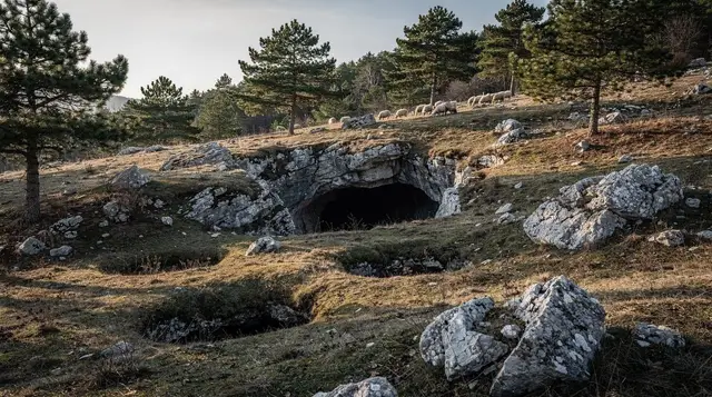
At roughly 1,469m above sea level, Lukomir is the highest permanently inhabited village in Bosnia and Herzegovina, and it looks the part: low stone houses with wooden shingle roofs, dry-stone enclosures, and pasture running out to the rim of a canyon. It is not preserved for visitors and it is not staged - it is a working summer settlement that empties for the winter, and the honest way to see it is as a place people still live, not a museum with an admission gate.
Bosnia’s highest village, not a museum
Lukomir’s isolation is the point and the difficulty in equal measure. The village sits on the Bjelašnica plateau, above the tree line, with the Rakitnica canyon dropping away just beyond its fields. A handful of families still keep the old rhythm: they move up with sheep and cattle in late spring, spend the summer in the stone houses, and come back down before the snow closes the track, usually by October or November. In deep winter almost nobody is there. What you find in July differs from what you find in May or September, and what you find in January is very little at all.
The houses themselves are the reason people come: thick stone walls, small windows, roofs of hand-split wooden shingles weighted with stones against the wind, arranged along narrow lanes with no attempt at symmetry. A small stone mosque and an old cemetery with distinctive carved headstones sit at the edge of the settlement. None of it is signposted for tourism in the way a heritage site would be - there are no information panels, no ticket booth, and no fixed opening hours, because it is somebody’s home rather than an attraction with a schedule.
Getting there: the road via Bjelašnica
The standard route from Sarajevo runs about 50km and takes roughly 1 hour 30 minutes by car, though the number is deceptive: most of that time is spent on the final unpaved stretch, not the highway kilometres. The usual path goes out through Ilidža toward the Bjelašnica plateau, climbing past ski infrastructure and open highland pasture before the tarmac ends. From there the track to Lukomir is gravel and packed earth, rutted in places, with drop-offs on one side in a few sections - manageable in a normal car in dry weather at low speed, uncomfortable and occasionally risky in a low-clearance rental after rain.
A capable vehicle matters more here than on most day trips out of Sarajevo. If you are driving yourself, check the forecast for the days before your visit as much as the day itself: a dry morning after a wet week can still mean soft, rutted ground. Renting through a car rental desk in Sarajevo, ask specifically about ground clearance and whether the contract allows unpaved roads - some do not. For anyone without their own transport, this is one of the clearer cases in the region for booking an organised trip rather than improvising.
an offroad 4x4 tour that handles the unpaved climb to Lukomir removes the vehicle question entirely and usually includes stops on the Bjelašnica plateau along the way.
On foot, by jeep, or by quad
There are several practical ways to reach the village, and which one suits depends on time, fitness, and whether you have a vehicle.
| Option | Typical duration from Sarajevo | Suits |
|---|---|---|
| Self-drive (4x4 or high-clearance car) | Half day | Confident drivers, dry season, own schedule |
| Guided hiking day trip | Full day | No car, want the plateau walk and a guide |
| Jeep or 4x4 tour | Half to full day | No car, prefer to sit and be driven |
| Quad tour | Half day | Wants a more active, faster ride up |
Walking to Lukomir is genuinely possible rather than a marketing phrase: a marked route crosses the open plateau from the Umoljani side, mostly on gentle gradient with long views rather than technical climbing, and takes most of a day there and back on foot. It is a good introduction to hiking around Sarajevo for anyone who wants a full day out rather than a short excursion.
a guided hiking day trip that walks the plateau route to Lukomir with transport both ways is the straightforward choice if you want the walk without route-finding or a rental car. A version built around a longer break at the top,
a hiking trip to Lukomir that includes a picnic lunch on the plateau, solves the food problem discussed below by bringing lunch rather than hoping to find it. For a faster, more active version of the same ground,
a quad tour across the Bjelašnica plateau to Lukomir covers the distance in less time and suits visitors who want the terrain without the full day’s walk.
What to see in the village
There is no formal circuit; Lukomir rewards slow walking through its lanes rather than a checklist. The stone houses and their shingle roofs are the obvious subject, best appreciated from slightly above the village on the approach track, where the layout against the plateau and the canyon edge is clearest. The small cemetery, with its carved and weathered headstones, sits near the village entrance and is worth a quiet look - it is an active burial ground, not a display. In summer, elderly residents sometimes sell knitted wool socks, gloves and other textiles directly outside their houses; buying something is a fair way to put money directly into the village rather than into a middleman.
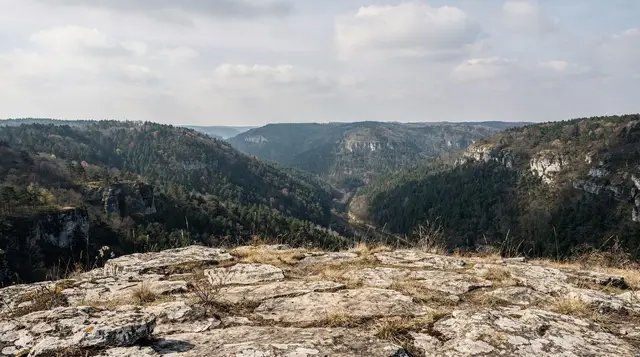
The land beyond the last houses drops toward the Rakitnica canyon, and the viewpoint at the rim is one of the more striking outlooks near Sarajevo - a straight several-hundred-metre drop into a narrow gorge, with the Visočica ridge visible on the far side. This is also where caution matters most: the edge is not fenced, the ground can be loose, and wandering further along the rim without local knowledge is not advisable given the wider landmine caution covered below. Treat the rim as a place to stop and look, not to explore.
When to go
Timing changes what kind of visit you get more than almost anywhere else covered in this guide. June through September is when the village is actually inhabited, the wildflowers are out on the plateau, and the unpaved road is at its most passable. Late spring and early autumn can still work but bring a real chance of mud or an early snow flurry at this altitude - check conditions before committing a whole day to it. From roughly November to April, snow typically closes the access track altogether and the handful of families who summer there have already moved down; a winter attempt is a mountaineering trip, not a day out, and not something to improvise.
If you are weighing this against other plans, it is worth reading when to visit Sarajevo more broadly, since the city’s own best months - May-June and September - line up closely with Lukomir’s accessible window.
Food, water and practicalities
Bring water and food from Sarajevo or from Umoljani on the way up. In peak summer, one or two Lukomir households sometimes offer simple food, coffee, or the wool goods mentioned above, but this is informal and depends on who happens to be in and willing that day - it is not a restaurant with hours you can plan around, and outside July and August it may not happen at all. There is no shop, no fuel, and no reliable mobile signal once you are on the plateau, so fill up the tank and tell someone your rough plan before you leave Sarajevo. Toilets are basic to non-existent; treat the visit the way you would any remote mountain outing.
Safety: stay on the marked track
The wider Bjelašnica-Rakitnica area still carries landmine risk left from the 1990s war, and this is not a historical footnote to skip past - it is the single practical safety rule for this trip. Stay on the visible vehicle track and any clearly marked walking trail; do not cut across open pasture to save time, and do not follow an unmarked path toward the canyon rim out of curiosity. Yellow and red hazard markers, where present, are not decorative.
For any hiking beyond the direct village approach - along the canyon rim, down toward the Rakitnica canyon trek, or further onto the plateau - go with a guide who knows the current cleared routes. The fuller picture is in landmine safety for hiking in Bosnia, and it applies here as much as anywhere in the country.
Lukomir and the Rakitnica canyon: two different visits
Lukomir and the Rakitnica canyon sit beside each other and are often mentioned in the same breath, but they are two different outings. This page covers the village: the houses, the cemetery, the plateau approach, the people who still summer there. The canyon is a separate, steeper undertaking - a marked descent into the gorge itself, covered in the dedicated Rakitnica canyon trek guide, with its own timing, difficulty and guide requirements. Visiting the village does not require descending into the canyon, and the canyon trek does not require lingering in the village; treat them as two decisions rather than one.
Planning your visit
| From Sarajevo | Distance | Typical time |
|---|---|---|
| Lukomir (via Bjelašnica) | ~50km | ~1h 30 |
| Umoljani (walking start point) | ~45km | ~1h 15 |
| Bjelašnica plateau | ~30km | ~45 min |
A Lukomir visit fits comfortably into a single day from Sarajevo, whether driven, walked, or booked as a tour, and does not need an overnight stay given the lack of reliable accommodation on-site. For a first visit without your own vehicle, a guided option is the more forgiving choice:
a guided day hike to Lukomir that combines the plateau walk with time in the village is built around exactly that combination of the walk and the visit, with transport handled at both ends.
If Lukomir is one stop among several on a longer plateau day, it pairs naturally with Umoljani and the wider Bjelašnica and Umoljani day trip, or with a broader look at day trips from Sarajevo if you are still deciding between destinations. Anyone driving themselves should also read driving in Bosnia beforehand, since the rules and road conditions differ from what EU or UK drivers are used to, and check Lukomir as a dedicated day trip for a route that treats the village as the whole day’s plan rather than one stop among several.
Overnighting near the plateau rather than in Lukomir itself is possible through the wider network of mountain huts around Sarajevo, useful for anyone combining this with an early start on the Rakitnica canyon trek the following day. More broadly, the trip fits the pattern covered in hiking around Sarajevo and belongs on the same list as the rest of the region’s mountains and peaks.
Frequently asked questions about visiting Lukomir
How far is Lukomir from Sarajevo and how long does it take?
About 50km, which takes roughly 1 hour 30 minutes by car. The route runs through Ilidža and up onto the Bjelašnica plateau; the last several kilometres are unpaved and slow, closer to 20-25km/h than motorway speed.
Do I need a 4x4 to reach Lukomir?
A standard car with reasonable ground clearance can usually make it in dry summer conditions, but the unpaved final stretch has ruts and loose stone that punish a low, soft-suspension rental. A 4x4 or an organised jeep tour removes the risk, and is close to essential after rain or any snow.
Is Lukomir open all year?
No. Lukomir is inhabited only from roughly late spring to early autumn, when a handful of families move up with their livestock. Snow closes the access track for a large part of the winter, and outside the warm months the village is largely empty.
Can I hike to Lukomir instead of driving?
Yes. A marked route crosses the Bjelašnica plateau from the Umoljani side, taking most of a day on foot, and guided hiking tours from Sarajevo cover the same ground with transport at each end. It is a plateau walk on open ground, not a technical trek.
Is there food or a café in Lukomir?
Sometimes, not reliably. In peak summer one or two households may serve simple food or coffee to visitors, but this is not a fixed restaurant with opening hours. Outside July and August, do not plan around finding a meal there - bring water and food from Sarajevo or Umoljani.
Is it safe to walk off the marked paths near Lukomir?
No. The wider Bjelašnica and Rakitnica area still has land flagged for landmine risk from the 1990s war. Stay on the visible track and any marked trail, do not cut across open pasture or into the canyon rim on a whim, and use a guide for anything beyond the obvious village approach.
Is Lukomir the same visit as the Rakitnica canyon?
No, though they sit next to each other. Lukomir is the village itself - houses, cemetery, pastures. The Rakitnica canyon is the steep gorge just below it, reached by a separate trail with its own guide, covered on its own page rather than folded into this one.
Should I visit Lukomir independently or on a tour?
Independently works if you have a capable vehicle, good weather, and no urgency about lunch. An organised tour - hiking, jeep, or quad - removes the driving risk, usually includes a guide who can explain what you are looking at, and is the more comfortable choice for a first visit or without your own car.
Mountain excursions on GetYourGuide
Verified deep-linked GetYourGuide tours. Book through these links and we earn a small commission at no cost to you.
GetYourGuide does not provide a product photo for this activity — the image shows the meeting point, photographed by us.