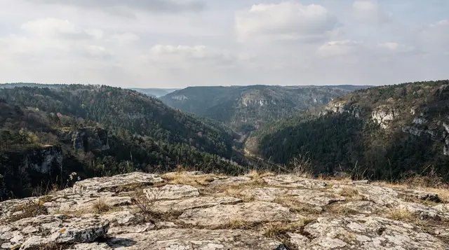
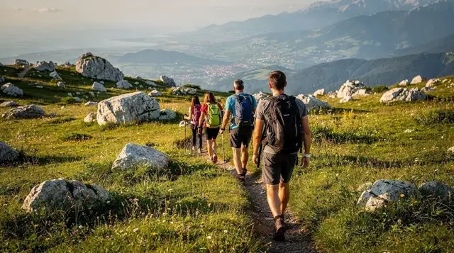
At 1,469 metres, Lukomir is the highest permanently inhabited village in Bosnia and Herzegovina, and it looks the part: a cluster of stone houses under wooden shingle roofs, sheep pens, and hay stacked against the wind, set on a treeless shoulder of the Bjelašnica massif above the Rakitnica canyon. It is roughly 50km from Sarajevo and takes about an hour and a half to reach, and a good part of that drive is on unpaved track. This is not a polished day-trip stop with a car park and a gift shop. It is a working pastoral settlement that a small number of families still return to every summer, and that is exactly what makes it worth the drive.
Bosnia’s highest village, above the tree line
Lukomir sits on the edge of the high plateau that runs from Bjelašnica towards the Rakitnica gorge, well above the last trees and well past the point where the road stops being reliable. The village is small: a few dozen stone houses, most roofed in wooden shingles rather than tile, arranged loosely along the contour of the hillside with no real centre or main street. Livestock still graze the surrounding pastures in summer, and the rhythm of the place follows the animals more than any tourist schedule.
What sets Lukomir apart from almost everywhere else on a Sarajevo itinerary is that it is genuinely seasonal. Snow cuts the village off from the rest of the country for a good part of the winter, and most of the families who keep houses here only live in them from late spring to early autumn, moving back down to lower villages once the cold sets in. Visit in January and you will find an empty, snowbound cluster of stone buildings. Visit in July and there are people, animals, washing on the line, and sometimes a household selling coffee or a simple meal to the hikers passing through.
Getting there: the road is the first decision
The drive from Sarajevo runs up through Umoljani and onto the Bjelašnica plateau before the final stretch to Lukomir, which is unpaved mountain track for the last several kilometres. In dry summer conditions a normal rental car can usually make it, carefully and slowly, but potholes and loose stone are a constant, and after heavy rain the surface gets significantly worse. There is no tarmac shortcut and no realistic detour: the state of that last piste is simply part of visiting Lukomir, and it is worth saying plainly rather than glossing over.
| Option | Time from Sarajevo | Approximate cost | Notes |
|---|---|---|---|
| Self-drive (own car or rental) | ~1h30 | Fuel only | Fine in dry summer conditions; slow and rough near the end |
| Taxi or private driver | ~1h30 each way | 100-150 KM (€51-77) return, negotiated | Agree the return pick-up time before setting off |
| Guided hiking or quad tour from Sarajevo | Half day to full day | Varies by tour | Transport, guiding and often lunch included |
| Public transport | Not available | – | No scheduled bus reaches Lukomir |
There is no public bus service to Lukomir, which is the main reason most visitors either drive themselves in summer or book an organised trip. For travellers without a car, a guided option is the simplest way to get there and back without worrying about the track or the return timing, and it comes with someone who actually knows the terrain around the village.
A guided hiking day trip to Lukomir with an English-speaking guide covers the drive, the village, and a walk out onto the plateau. If you want something a little different, a quad-bike route up onto the Bjelašnica plateau to Lukomir covers the same ground on wheels rather than on foot.
What Lukomir actually looks like
The houses are built low and solid, in undressed stone, with wooden shingle roofs weighted down with stones against the wind that rarely stops up here. There is no grid of streets in any conventional sense; buildings sit where the slope and the old field boundaries put them, connected by dirt paths worn in by decades of foot and hoof traffic rather than laid out on purpose. Sheep are everywhere in summer, along with the occasional cow, and stone-walled pens and hay racks are as much a part of the view as the houses themselves.
This is still, first and foremost, a place people work rather than a heritage display built for visitors. Some households keep a small stand or a table where they sell coffee, honey, cheese, or a simple plate of food to passing hikers in the height of summer, but this is informal and not guaranteed on any given day, so bring your own water and something to eat regardless. Toilets are basic to non-existent. Mobile signal is patchy at best once you are off the plateau road.
Lukomir versus Umoljani: not the same trip
Umoljani, lower down the same road, is the easier and more visited of the two villages: a better surfaced approach, several guesthouses and restaurants, and enough day-trippers in summer that it functions as a small tourism economy of its own. It is a reasonable stop, and a fine base if you want a comfortable night on the plateau.
Lukomir is a further, rougher drive beyond it, and a genuinely different experience. Where Umoljani has adapted to visitors, Lukomir has stayed a working village that visitors are allowed to pass through. If your time only allows one of the two and you want the higher, quieter, more traditional destination, that is Lukomir; if you would rather have easier access, a place to eat, and a comfortable base for exploring the wider Bjelašnica and Igman area, Umoljani serves that purpose better. Several organised itineraries cover both in the same day, which is a sensible way to compare them for yourself.
Walking out from Lukomir: the Rakitnica canyon
Lukomir’s other role, beyond being a destination in itself, is as the practical starting point for walks into the Rakitnica canyon, one of the deepest and least developed gorges in the country. A short walk from the village brings you to viewpoints looking down into the canyon, which is worthwhile on its own and takes under an hour. Descending into the canyon itself is a different proposition: several hours of hiking on largely unmarked, exposed terrain, not something to attempt without preparation or local knowledge.
For a longer, more demanding day that combines the village with real hiking, a longer guided hike that adds the summit of Obalj to the Lukomir village visit is built for exactly this. Read the dedicated Rakitnica canyon trekking guide before attempting the descent independently, and see the general hiking around Sarajevo and Lukomir hike guide pages for route options that stop at the viewpoints rather than going all the way down.
When to go
Lukomir is a strictly seasonal destination, more so than almost anywhere else within day-trip range of Sarajevo. The unpaved approach can be snowbound or simply impassable for a large part of the winter, and most of the households that use the village only occupy it from roughly late spring to early autumn.
| Season | Conditions | Verdict |
|---|---|---|
| Late May-June | Green, cooler, fewer visitors | Very good |
| July-August | Warm, most households present, busiest | Good, book ahead for guided trips |
| September-early October | Clear air, harvest activity winding down | Very good |
| November-April | Snow likely, road often closed, village largely empty | Avoid unless conditions are confirmed |
If you are also planning higher-altitude days on Jahorina or around Bjelašnica, the same late-spring-to-early-autumn window applies for comfortable hiking; outside it, those mountains switch over to their ski season instead, which is a different kind of trip covered on the skiing near Sarajevo guide rather than this page.
Practicalities and safety
Bring cash: Lukomir is not a place with card machines, and any food, coffee, or honey sold by a household will be a small cash transaction. Bring more water than you think you need, sun protection even on a cool day, and proper footwear for uneven stone paths rather than trainers. Layer clothing regardless of season; the plateau is exposed and the wind changes the felt temperature quickly even in summer.
The one safety point worth repeating clearly: parts of the wider Bosnian countryside, including areas around some mountain trails, are still marked as suspected minefields from the 1990s war. The paths in and immediately around Lukomir that are in regular use by locals and hikers are safe and walked constantly. The risk is leaving marked, well-trodden paths for what looks like a shortcut or a better view.
Respect any yellow or red warning markers without exception, stick to routes that are clearly in current use, and take a guide for anything beyond them, particularly around the Rakitnica canyon edges. The landmine safety guide for hiking in Bosnia sets out the rules in full and is worth five minutes before any independent hike in this region.
Independent visit or guided tour
Driving yourself to Lukomir works well in summer if you are comfortable with an unpaved mountain track and want to set your own pace at the village and the canyon viewpoints. It gives you flexibility, but no local context beyond what you read in advance, and no easy fallback if the track conditions or weather turn against you.
A guided trip removes the driving and routing decisions entirely, adds a local perspective on a village that has no signage to explain itself, and is the only realistic option if you do not have a car. Beyond the hiking options already mentioned, a Lukomir hike that includes a picnic lunch on the plateau is a straightforward way to do the trip without worrying about food. For a broader comparison of doing Bosnia independently versus with a guide, see guided tour versus independent Bosnia.
If you would rather combine Lukomir with other nearby highlights in one organised day, the Bjelašnica and Umoljani day trip guide and the general best day trips from Sarajevo and day trips without a car pages lay out the alternatives, and the standalone Lukomir day trip guide walks through a full itinerary for this specific destination. Travellers building a longer nature-focused stay might also look at the Bosnia nature week itinerary, which places Lukomir alongside the other mountain and canyon destinations in this region.
Lukomir questions answered
How do you get to Lukomir without a car?
There is no public bus to Lukomir. Independent travellers without a car normally book a guided hiking or quad tour from Sarajevo, or hire a driver for the day. A taxi from Sarajevo will do the run, but agree the return time and price before you set off, since there is no phone signal in parts of the village to call another one.
Can you drive to Lukomir in a normal rental car?
You can, in dry summer weather and with care, but the last stretch beyond Umoljani is an unpaved mountain track with potholes and loose stone. After rain or in early spring it gets rough enough that a higher-clearance vehicle is genuinely worth it. Check current road conditions before you go, and never attempt it in snow.
How long is the hike from Lukomir into the Rakitnica canyon?
The viewpoint above the canyon is a short walk from the village, but the descent into the Rakitnica canyon itself is a proper hike of several hours there and back, on unmarked and exposed terrain in places. Go with a guide unless you know the route, and see the dedicated Rakitnica canyon guide before you commit to it.
Is Lukomir dangerous because of landmines?
The marked paths around Lukomir and the village itself are safe and walked daily. The risk in this part of Bosnia and Herzegovina is straying off marked trails into unswept ground, not the village. Stay on paths that are clearly in use, respect any yellow or red warning signs, and take a guide for anything beyond the well-trodden routes.
What is the difference between Lukomir and Umoljani?
Umoljani is the lower, easier village on the same high plateau, reached on a better road, with more guesthouses and day-trippers. Lukomir sits higher, further along a rougher track, and is the more remote, more traditional destination of the two. Many day trips visit both; if you only have time for one and want the higher, quieter village, that is Lukomir.
Is Lukomir accessible in winter?
Rarely. Snow closes the unpaved approach for long stretches of the winter, and most of the families who live there in summer leave before it does. Plan a Lukomir visit for late spring through early autumn, and treat any winter trip as weather-dependent even with a 4x4.
Can you stay overnight in Lukomir?
A small number of households take guests in summer, more as informal homestays than as bookable hotels, so arrange this locally or through a guide rather than expecting an online listing. Most visitors see Lukomir as a half-day or full-day trip from Sarajevo rather than an overnight stop.
Is there food and water available in Lukomir?
In the summer months, at least one household or small stand in the village serves simple food and drinks to visitors, but this is not guaranteed and varies year to year. Bring your own water and some food for the road, especially outside the peak summer weeks.