Not the same place as Visoko
Get this out of the way first, because the two names trip up a lot of people planning a Bosnia trip. Visočica is a mountain in the range between Bjelašnica and Konjic, reached on foot, with no roads to the summit and no facilities once you leave the last village.
Visoko is a separate town roughly 30 km north of Sarajevo, on the road toward Zenica, best known for the so-called Bosnian pyramids — a claim the scientific community has rejected outright, and one Bosnian archaeology has formally distanced itself from. If a search engine or a guidebook index led you here looking for the pyramids, you want Visoko, not this page, and you’ll find the honest version of that story on our Visoko and Bosnian pyramids pages. If you actually want the hills that photograph as green ridgelines and empty huts, keep reading.
Visočica itself is not a household name even among people who hike regularly around Sarajevo. It doesn’t have Bjelašnica’s ski infrastructure, Jahorina’s resort base, or Lukomir’s reputation as the highest inhabited village in the country. What it has is proximity to two better-known areas — the Olympic mountain plateau and the Konjic side of the Neretva valley — and a genuine sense of being away from the trail traffic that builds up on the marked Bjelašnica routes in July and August.
Where it sits, and why so few people come here
Visočica rises on the southern side of the Bjelašnica–Konjic massif, in the stretch of high ground that also holds the Rakitnica canyon and the pastures around Umoljani and Lukomir. It’s not a single dramatic peak the way Maglić is inside Sutjeska National Park; it’s a broader upland area of ridges, karst pasture and forest, sitting a little apart from the well-trodden Bjelašnica ski-lift approach and from the Konjic-to-Boračko Lake road.
That in-between position is exactly why it’s quiet. Day-trippers from Sarajevo who want a mountain walk default to Bjelašnica, because it’s closer, better signposted, and has a cable car and mountain huts to anchor the day. Hikers chasing a specific, famous destination go to Lukomir, because it’s the highest village and the Rakitnica canyon views are genuinely spectacular. Visočica doesn’t have either of those hooks. What it offers instead is solitude, unbroken ridgeline walking, and — depending on the route — views down into the Rakitnica gorge from a different angle than the standard Lukomir vantage points.
Getting to a trailhead
There is no single obvious starting point the way there is for Bjelašnica’s cable car or Lukomir’s access road. Two approaches are used in practice:
From the Bjelašnica plateau. Drive up toward Bjelašnica as if heading for the ski area, then continue on the unpaved plateau roads that link toward Umoljani and the Rakitnica rim. From this side, Visočica is reached by continuing along ridge tracks rather than dropping down. Allow around an hour from Sarajevo to reach the plateau itself, then further time on foot or by 4x4 track depending on where the walking starts.
From the Konjic side. Drive to Konjic — about an hour from Sarajevo on the motorway — then head up into the hills on the west side of the Neretva valley. This approach tends to be used by hikers combining Visočica with a wider loop through the Konjic uplands, sometimes as a two- or three-day traverse rather than a single out-and-back.
Neither approach has a car park with a signposted trailhead in the way Bjelašnica’s cable-car base does. Tracks are unpaved, sometimes rutted, and a normal city rental car will struggle on the roughest sections — this is one of the areas of the country where hiring something with real clearance, or arranging a guide with their own 4x4, actually matters rather than being a nice-to-have.
The routes up
Because this isn’t a maintained tourist route, “the route up Visočica” isn’t a single fixed path the way the Bjelašnica cable-car-to-summit walk is. Local hiking clubs and mountain guides run several lines depending on season, snow cover the previous winter, and which approach you’re starting from. What’s consistent across all of them:
- Waymarking is sparse to non-existent above the last farm tracks. Where markers exist, they’re the red-and-white circles used across the Dinaric ranges, but stretches go unmarked for long distances.
- Mobile signal is unreliable to absent for most of the route once you’re past the last village.
- There’s no hut, kiosk, or water point on the mountain itself. Whatever you carry in is what you have.
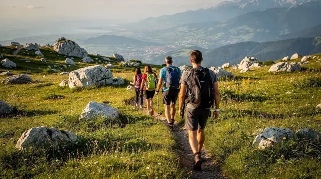
- Terrain shifts from forest track to open karst pasture to rockier ridge walking, with no technical climbing involved on the standard lines, but plenty of ground where a wrong turn in poor visibility or low cloud costs real time.
This is the profile of mountain that Bosnian hiking clubs list as “orientation required” rather than “waymarked trail” — a paper map and compass, or a GPS track downloaded in advance, rather than relying on a phone app that assumes signal or a cached map that turns out to be missing the side tracks. If that sentence makes you want a guide rather than a solo attempt, that’s the sensible reaction, not an overcautious one.
a guided day hike through this stretch of the Olympic mountains, with lunch included covers exactly this kind of terrain with someone who already knows the current state of the tracks, which matters more here than on Bjelašnica’s marked routes.
What you’ll actually see
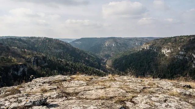
Don’t expect a single famous viewpoint or a landmark building. What Visočica offers is the cumulative experience of ridge walking through pasture and forest with almost nobody else around: shepherd huts, some still used seasonally and some abandoned; wide views west toward the Konjic hills and, on clear days, back toward the higher peaks of the Bjelašnica massif; and, depending on the exact line taken, glimpses down into side branches of the Rakitnica system that don’t get the crowds of the main Lukomir viewpoints.
It’s a landscape of subtlety rather than a single postcard shot — closer in feel to the Sutjeska approach trails than to the manicured overlooks near Trebević. If your Bosnia trip is built around one or two headline sights per day, this isn’t the priority stop. If you’ve already done Bjelašnica, Lukomir and the Rakitnica canyon, and you want a second, quieter day in the same general area, it’s a legitimate next step.
Stay on the marked and known paths
This is worth repeating on every page about hiking in Bosnia and Herzegovina’s more remote hill country, and it applies here as much as anywhere: parts of the country still carry suspected landmines left from the 1992-95 war, decades after the fighting ended. The rule is simple and non-negotiable — never leave marked trails, established tracks, or areas you know to be cleared and in regular use, and treat any yellow or red warning sign as absolute.
Visočica isn’t flagged as a high-risk area the way some specific hillsides are, but it’s exactly the kind of lightly-used, lightly-marked upland terrain where “I’ll just cut across that meadow to save twenty minutes” is the wrong instinct. If you’re not hiking with someone who knows the ground, stick to tracks that show recent use by vehicles or livestock, and hire a guide for anything off that.
Beyond that specific risk, treat this as genuine backcountry: tell someone your planned route and return time, carry more water than you think you need, pack a paper map or a downloaded GPS track rather than relying on a live signal, and start early enough that a slower-than-planned day still gets you back to the car in daylight. There’s no mountain rescue infrastructure comparable to the Alps here, and the nearest help, if something goes wrong, is a phone call away only if you happen to be on a ridge with signal.
The wider Konjic–Bjelašnica upland, for context
Visočica sits inside a broader stretch of high country that rewards a few days rather than a single visit, if hiking is genuinely your priority in Bosnia. Bjelašnica itself, with its 1984 Olympic ski history, has the best-marked network and the only cable-free chairlift access in the area. Umoljani and Lukomir add the stone-roofed village and the Rakitnica rim.
Further south, Konjic anchors the valley side, with Tito’s Cold War bunker as an unrelated but genuinely worthwhile stop on the way in or out. Further again, Sutjeska National Park and the old-growth Perućica forest hold the country’s actual highest peak, Maglić, for hikers who want to go further into the mountains than a single day trip allows.
Visočica doesn’t compete with any of these for name recognition, and it shouldn’t be your only mountain day in Bosnia. It’s a good second or third day for someone who has already done the obvious stops and wants more of the same landscape with fewer people on it.
| Mountain | Marked trails | Facilities | Crowds | Best for |
|---|---|---|---|---|
| Bjelašnica | Well marked | Cable car, huts, restaurant | Moderate to busy | First-time visitors, ski history |
| Jahorina | Well marked near resort | Resort infrastructure, hotels | Busy in ski season | Families, resort-based stays |
| Lukomir / Rakitnica | Marked access road, trail less so | Village guesthouses, none on the canyon rim | Moderate, growing | The highest-village experience |
| Visočica | Sparse to unmarked | None | Very light | Experienced hikers, guided days, solitude |
Practicalities
There’s no entrance fee, no visitor centre, and nothing to book in advance if you’re going independently with your own transport and navigation — which is also exactly why independent visits aren’t the right call for most travellers. A realistic day budget covers fuel or a guide’s rate, food you carry in, and nothing else; there’s nowhere on the mountain to spend money even if you wanted to.
Water: carry all of it. There are no reliable, treated sources along the standard lines, and springs that do exist shouldn’t be assumed safe without local knowledge of exactly which one and when.
Phones: expect patchy to no signal above the last farms. Download offline maps before you leave Sarajevo or Konjic, not when you’re already on the plateau.
Timing: this is a full-day undertaking once you count the drive to the trailhead, the walk itself, and the drive back. It doesn’t combine well with a second major stop the same day — pick Visočica as the day’s plan, not as an add-on to Konjic’s bunker or to Boračko Lake.
For most visitors, a guided option removes the two real obstacles — orientation on unmarked ground and the drive on unpaved plateau tracks — without losing the point of the day, which is the quiet. A guided hiking day from Sarajevo into the Lukomir and Rakitnica side of this same range covers adjacent terrain with a guide who knows current trail conditions, and the version that includes a picnic lunch on the trail works well if you’d rather not carry and plan food yourself.
When to go
June through September is the realistic window. Snow lingers into May at this altitude in a normal year, and by October the days are noticeably shorter, which matters on a route with unmarked stretches where losing daylight is a real problem rather than an inconvenience. Winter hiking here isn’t something to attempt without local mountaineering experience and the right equipment — there’s no equivalent of Bjelašnica’s or Jahorina’s groomed winter infrastructure. If a winter mountain day is what you want, skiing near Sarajevo at Bjelašnica or Jahorina is the honest answer, not Visočica.
Midsummer weekday mornings, starting early to beat any afternoon cloud building over the ridges, give the most reliable combination of clear views and manageable heat.
Questions about hiking Visočica
Is Visočica the same as Visoko and the Bosnian pyramids?
No. Visočica is a mountain in the Bjelašnica-Konjic range with no connection to Visoko, a town north of Sarajevo where the disputed “Bosnian pyramids” claim originated. The scientific consensus is that Visoko’s hills are natural formations, not pyramids. If you’re after the pyramids story, look at our Visoko and Bosnian pyramids pages, not this one.
Can I hike Visočica without a guide?
Experienced hikers with proper navigation — a downloaded GPS track or a topographic map, not just a phone app assuming signal — do go independently. For most visitors, especially anyone not used to unmarked Balkan mountain terrain, a local guide is the sensible choice, both for orientation and because a guide will know the current state of tracks that change from season to season.
Are there marked trails to the summit?
Waymarking is sparse and inconsistent compared with Bjelašnica or the Lukomir access road. Some stretches carry the standard red-and-white markers; long sections have none. Treat this as backcountry navigation, not a signposted walk.
Is it safe regarding landmines?
Stick strictly to marked tracks and paths in regular use, and never cut across open meadow or forest to shortcut a route. Suspected mined areas remain in parts of rural Bosnia and Herzegovina decades after the war; Visočica isn’t specifically flagged as high-risk, but the same absolute rule about staying on known ground applies here as anywhere in the country’s remoter hills.
How do I get to the trailhead without a car?
There’s no public transport to either approach — the Bjelašnica plateau tracks or the Konjic-side hills. A rental car with real ground clearance, a private driver, or a guided tour with its own transport are the only realistic options.
Can I combine Visočica with Lukomir or Konjic in one day?
Not comfortably. Each is a full day once you count driving time and the walk itself. Treat Visočica, Lukomir and Rakitnica, and Konjic’s bunker as separate days if you want to do all three properly rather than rushing each one.
Is there anywhere to eat or stay on the mountain?
No. There are no huts, kiosks, or accommodation on Visočica itself. Eat before you leave Sarajevo or Konjic, carry food and water for the full day, and plan to be back in a village or town by evening.
What should I pack?
Sturdy hiking boots, layers for temperature swings between the valley and the ridge, more water than a marked-trail day would require, a paper map or offline GPS track, and a fully charged phone with an offline map downloaded in advance. In shoulder season, add a warm layer and rain protection regardless of the morning forecast.