A week of hiking and national parks in Bosnia and Herzegovina
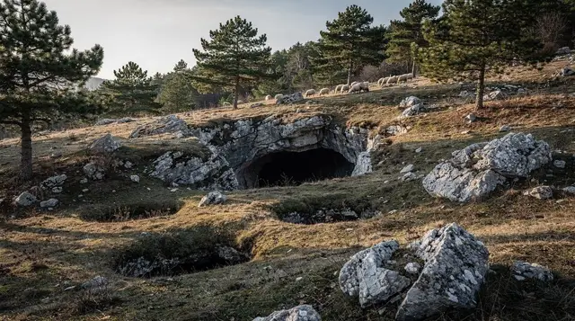
Sarajevo sits in a ring of mountains, and most visitors never get past the cable car and the viewpoint above Trebević. This route does the opposite: seven days spent almost entirely outside the city, in the high pastures above Bjelašnica, the stone village of Lukomir, the primeval forest inside Sutjeska National Park, and the waterfalls of Una National Park near the Croatian border.
There is no museum on this itinerary and no memorial stop — it’s the most nature-focused week the site plans, and it covers real distances, so pack accordingly and read the landmine safety guide before you go.
Overview
| Day | Base | Focus | Distance from Sarajevo |
|---|---|---|---|
| 1 | Bjelašnica | Arrival, plateau walk | 30 km / 45 min |
| 2 | Lukomir | Village, ridge trail | 50 km / 1 h 30 (track) |
| 3 | Lukomir / Umoljani | Rakitnica Canyon trek | — |
| 4 | Konjic | Neretva rafting | 60 km / 1 h |
| 5 | Sutjeska (Tjentište) | Perućica primeval forest | 130 km / 2 h 30 |
| 6 | Sutjeska | Maglić or Trnovačko Lake | — |
| 7 | Una National Park | Štrbački buk, transfer | ~300 km / 4 h 30 (via Bihać) |
Difficulty is rated challenging for the week as a whole — the Rakitnica descent and a Maglić attempt are genuinely strenuous days — though individual days can be softened; ask any operator about shorter options if you’re travelling with less-experienced hikers.
Before you go: the mine rule
This bears repeating once, clearly, before anything else. Land mines from the 1992–1995 war are still suspected in parts of rural Bosnia and Herzegovina, away from villages and marked paths. The rule for this entire week is simple and non-negotiable: never leave marked trails or visited areas, respect any yellow or red warning signage without exception, and take a guide for terrain beyond the well-trodden routes — that includes the Rakitnica canyon and any off-piste detour around Sutjeska or Una. It is not a reason to avoid the mountains; it is the reason to hike them with someone who knows the ground.
Day 1: Sarajevo to Bjelašnica
Bjelašnica is a 30-kilometre, 45-minute drive from central Sarajevo, and it’s the easiest possible introduction to this week: the mountain hosted the men’s alpine skiing at the 1984 Winter Olympics, and the plateau above the old ski station opens onto rolling, treeless grassland that feels far higher and wilder than the short drive suggests. Spend the afternoon on an easy loop around the plateau to acclimatise — nothing technical, just legs and lungs adjusting to altitude before the harder days ahead.
a quad-bike run up onto the Bjelašnica plateau and down toward Lukomir is a fast, fun way to cover the same ground if you’d rather not walk it on day one. Overnight in one of the small mountain lodges near the plateau; book ahead in July and August. See the hiking around Sarajevo guide for other short options if you arrive with an afternoon to spare before this itinerary starts.
Day 2: Bjelašnica to Lukomir
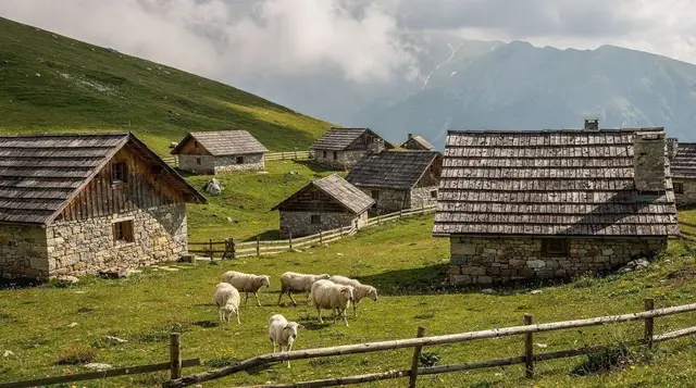
Lukomir, at roughly 1,469 metres, is the highest permanently inhabited village in the country: stone houses under wooden-shingle roofs, cut off by snow for part of the winter, with the last families still summering there and grazing sheep on the surrounding slopes. The track from Bjelašnica takes about an hour and a half; it’s unpaved and rough enough that most visitors join a tour rather than self-drive it, especially after rain.
a combined Igman and Bjelašnica mountain tour that also stops in Umoljani covers this leg well if you want the wider area in one day, pairing Lukomir with the neighbouring valley village of Umoljani and its old watermills. Alternatively, book straight through with a guided hiking day to Lukomir from Sarajevo, which walks a ridge trail rather than just driving the track. Overnight in a village guesthouse in Lukomir — simple, family-run, and the only way to see the village empty of day-trippers in the early morning. For route planning, the Lukomir hike guide has more detail on trail conditions by season.
Day 3: The Rakitnica Canyon
This is the hardest single day of the week. The Rakitnica Canyon cuts deep below Lukomir and the neighbouring Visočica massif, and the descent to the river and back out is a full day of steep, rough walking with real elevation change — plan on six to eight hours depending on the exact route and your pace.
a guided Lukomir and Obalj Peak hiking day covers the canyon rim and a summit alongside it, with a guide who knows exactly where the marked trail runs — worth repeating: the paths below the rim are not consistently signed, and a guide here is standard practice, not a luxury. Read the Rakitnica Canyon trek guide for what to expect before booking. Return to Lukomir or on to Umoljani for the night, ready for the transfer south the next morning.
Day 4: Konjic and rafting the Neretva
From Lukomir or Sarajevo, Konjic is about an hour by road — an easy transfer day with the main event on the water. Rafting the upper Neretva from Konjic runs from May to September, graded for beginners, with no previous experience required; the river here is fast enough to be genuinely exciting without the harder grades found further downstream. Wetsuits and equipment are provided by the operators; bring a swimsuit and a towel and expect to get thoroughly wet regardless of the weather.
The rafting the Neretva guide and the rafting season and safety guide cover water levels and what a typical run involves. If time allows, spend the afternoon at Boračko Lake, a glacial lake a short drive from Konjic, calm water ringed by pine forest — a good, easy counterpoint to the morning’s rapids. Overnight in Konjic or by the lake.
Day 5: Sutjeska National Park and the Perućica forest
Sutjeska is the country’s oldest national park, established in 1962, and it’s a genuinely different landscape from anything earlier in the week: deep, forested valleys running up to the Maglić massif on the border with Montenegro. From Konjic, budget roughly two and a half to three hours to reach Tjentište, the park’s main base, adjusting for the Konjic starting point rather than Sarajevo’s 130-kilometre figure.
The Perućica primeval forest is the reason to build a whole day around this stop: it’s one of the last two primeval forests left in Europe, and access is guide-only, arranged through the park administration — not a formality but a real restriction, both to protect the forest and because the terrain disorients easily without local knowledge. The Sutjeska and Perućica guide explains how to arrange a guide and what the walk covers; book this ahead rather than assuming you can turn up and join one.
Day 6: Maglić or Trnovačko Lake
Two realistic options from Tjentište, and which one you choose depends on fitness and weather. Maglić, at 2,386 metres, is the highest peak in the country and a serious mountain day — a long approach, real elevation gain, and a summit push that should not be attempted in poor visibility or without checking conditions locally first. The guide to Maglić and the high peaks lays out the standard route and where to base yourself the night before.
The gentler alternative is a guided hike to Trnovačko Lake with a picnic lunch included — a glacial lake below the ridgeline, a full but far less demanding day than a Maglić attempt, and a sensible choice if the group’s fitness is mixed. Either way, if you’re staying in the park’s mountain huts rather than in Tjentište itself, the mountain huts guide covers what to expect from Bosnian planinarski domovi generally.
Day 7: Una National Park and Štrbački buk
Be honest with yourself about this day before you commit to it: Sarajevo to Bihać is around 300 kilometres and four and a half hours by road, and Tjentište is further still from Bihać than Sarajevo is, so this is a long transfer, not a quick detour. Leave early, and don’t plan anything demanding for the afternoon beyond the waterfall itself.
Štrbački buk is the reward: a roughly 24-metre curtain of water on the Una, one of the clearest rivers in Europe, with wooden walkways letting you get close to the falls from several angles. Una National Park more broadly is worth an extra half-day if your schedule allows it — river beaches, smaller cascades, and Martin Brod further downstream. The Una National Park guide has the practical detail on access and where to swim.
Given the distance, most people treat this as the end of the loop rather than a there-and-back from Sarajevo: either overnight near Bihać and fly out via Sarajevo the next day, or continue on toward Croatia, since Bihać sits close to the border. If you do need to return to Sarajevo to fly home, budget the full four and a half hours again and don’t schedule anything tight against a flight. The driving in Bosnia and car rental in Sarajevo guides are worth reading before this leg if you’re self-driving rather than joining a multi-day tour that includes the transfer.
Planning notes
This week only works well outside winter — realistically May to September, which also happens to be rafting season on the Neretva. The best time to visit guide has the fuller seasonal picture, but for this specific route: snow can linger on the Bjelašnica and Sutjeska high ground into May, and Lukomir’s guesthouses generally close over winter. Pack for mountain weather that changes fast even in July — see the packing list — and bring cash; card machines are unreliable in Lukomir, Tjentište and the Una villages.
Budget mid-range for the week once you count guesthouse stays, a rafting trip, and one or two guided hiking days; it comes in noticeably cheaper than an equivalent week of guided hiking in the Alps or Dolomites, largely because guesthouse and guide rates in rural Bosnia and Herzegovina stay well below Western European prices. If seven days is more than you have, the three-day Sarajevo-Mostar itinerary or the fuller seven-day Bosnia road trip, which mixes towns and nature, are worth comparing against this purely outdoor version.
FAQ: hiking and national parks in Bosnia and Herzegovina
Do I need a car for this itinerary?
Not necessarily. Bjelašnica, Lukomir, Umoljani and the Neretva rafting put-in near Konjic all run as organised day tours from Sarajevo. Sutjeska and Una National Park are far enough that most visitors either join a multi-day guided trip or rent a car for that leg; see our guide to car rental in Sarajevo if you’d rather self-drive the whole week.
Is it safe to hike off the marked trails?
No. Bosnia and Herzegovina still has land mines suspected in areas away from cleared paths and villages, a legacy of the 1990s war. Stay on marked trails and in visited areas at all times, respect yellow and red mine-risk signage, and hire a licensed guide for anything beyond the well-known routes, including the Rakitnica canyon and Perućica forest.
How difficult is the Rakitnica Canyon trek from Lukomir?
It’s a full, physically demanding day: steep descents and re-ascents on rough ground, several hours of walking, and no phone signal for long stretches. A guide is standard practice, not an optional extra, since the trail network below the canyon rim is unmarked in places.
Why is Perućica forest guide-only?
Perućica is one of the last primeval forests left in Europe, protected inside Sutjeska National Park since 1954. Access is restricted to guided groups arranged through the park administration, both to protect the forest and because the terrain is genuinely disorienting without local knowledge.
When is rafting season on the Neretva?
May to September, with the strongest flow and coolest water in May and June. Konjic, about an hour from Sarajevo, is the usual put-in for the upper Neretva; trips are graded for beginners and no experience is required.
Is Štrbački buk worth the distance from Sarajevo?
It’s a genuinely long way — Sarajevo to Bihać is around 300 km and four and a half hours by road — so treat Una National Park as the far end of this trip rather than a quick add-on. Most visitors either overnight near Bihać or continue on toward Croatia rather than driving back the same day.
What should I pack for a week like this?
Proper hiking boots, layers for mountain weather that changes fast even in summer, a rain shell, and a swimsuit for Neretva rafting and the Una’s pools. See our packing list for the fuller checklist.
Hiking & nature tours on GetYourGuide
Verified deep-linked GetYourGuide tours. Book through these links and we earn a small commission at no cost to you.
GetYourGuide does not provide a product photo for this activity — the image shows the meeting point, photographed by us.