Bjelašnica in summer: hiking, biking and the road to Lukomir
Is Bjelašnica worth visiting in summer, when there's no snow?
Yes. The 1984 men's downhill mountain, about 30km and 45 minutes from Sarajevo, turns into a hiking and mountain-biking base once the snow melts, with clear panoramas over the Miljacka valley and the only paved road onto the high plateau towards Lukomir and Umoljani. Some Olympic-era lift stations are ruined and photogenic, others have been rebuilt and run in summer.
A ski mountain with nothing to do with skiing for eight months of the year
For most visitors, Bjelašnica means one thing: the mountain that hosted the men’s alpine skiing events at the 1984 Winter Olympics, the same games that put Jahorina, Igman and Trebević on the map. That’s a fair association, but it leaves out most of the calendar. From late spring to early autumn, the slopes that carried downhill racers in February carry hikers, mountain bikers and day-trippers heading for the high plateau above the village, on the way to Lukomir and Umoljani. This guide is about that other Bjelašnica: the one without snow, about 30km and 45 minutes from central Sarajevo.
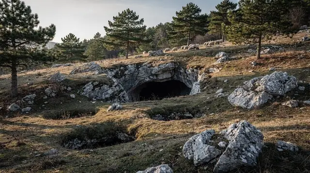
It’s worth being upfront about the split identity of the place. Bjelašnica in summer is not a polished resort experience. Some of the 1984 infrastructure has been rebuilt and reopened; a good deal of it hasn’t. Rusted chairlift pylons stand next to renovated hotel buildings. That contrast, rather than any single attraction, is a large part of what makes the mountain worth the drive.
What the 1984 Olympics left on the mountain
Bjelašnica staged the men’s downhill, slalom, giant slalom and combined events during the 8–19 February 1984 Winter Olympics, the games that put Sarajevo on the world sporting map for a fortnight. The infrastructure built for that fortnight, hotels, lift stations, a purpose-built ski settlement near the top of the road, was never designed to survive a war and a long stretch of underinvestment afterwards, and it shows.
Walking or driving up from the village, you’ll pass buildings in three states: some still standing but empty and stripped, some rebuilt as functioning hotels or apartments catering to the winter ski trade, and a smaller number restored specifically because of their Olympic history. None of it is curated as a museum piece in the way Trebević’s abandoned bobsleigh track has become, almost accidentally, one of the most photographed places in the region. Bjelašnica’s ruins are quieter and more scattered, met on the way to somewhere else rather than as a destination in themselves.
If the Olympic history is the reason you’re going, it’s worth reading up before you arrive, since very little on the mountain is signposted or explained on site.
a guided half-day trip up Bjelašnica that includes the cable car and an explanation of the 1984 venues covers this gap, and it’s the simplest way to see both the Olympic infrastructure and the summer views without needing your own transport.
Hiking straight from the top of the road
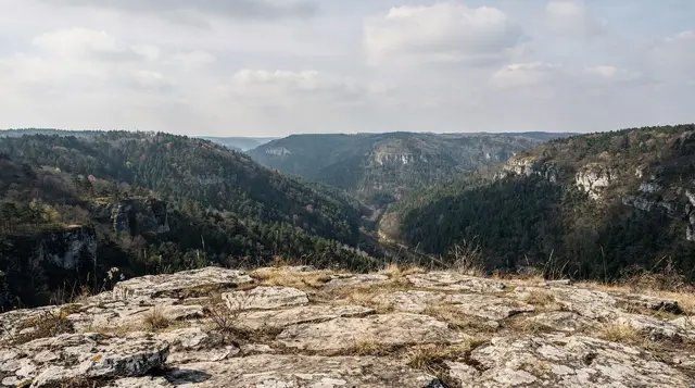
The paved road climbs to a car park and small cluster of hotels and cafés near the top station, at an altitude that makes a real difference to the temperature even in the height of summer. From there, several waymarked routes fan out across open, grassy upland with long views back down towards Sarajevo and the Miljacka valley.
None of these routes is technical. They’re mostly rolling grassland and gravel track rather than scrambling terrain, which is part of why Bjelašnica works as a half-day outing rather than a serious mountaineering trip. The one hard rule applies everywhere in this landscape and is worth repeating without apology: stay on marked paths.
Parts of the Bjelašnica and Igman uplands were front lines or troop positions during the 1992–96 war, and suspected minefields remain in places away from the well-used tracks and roads. This isn’t a reason to avoid the mountain, since the main routes to the viewpoints, to Umoljani and to Lukomir are established and walked daily in summer, but it is a reason never to wander off them out of curiosity, and to take a guide for anything beyond those known lines.
For a longer day, the track continues towards Rakitnica canyon, a deep, largely untouched gorge cut into the plateau’s edge, though this stretch is better done with a local guide who knows the current state of the path rather than attempted solo from a map.
The road to Lukomir and Umoljani
The single most useful fact about Bjelašnica in summer is that the road onto the plateau doesn’t stop at the ski station. It continues, first as tarmac and then increasingly as an unpaved mountain track, out to Umoljani and on to Lukomir, at around 1,469m the highest permanently inhabited village in Bosnia and Herzegovina. This is the route most day trips out of Sarajevo are actually built around, and Bjelašnica functions as the gateway rather than the final stop.
Umoljani is the more accessible of the two, a small farming settlement with stone houses, home-cooked meals available in summer, and access to the Rakitnica canyon rim. Lukomir sits further out and higher, cut off by snow for much of the winter and only fully inhabited again once the last families return in late spring. Both are covered in more depth elsewhere; this page is about the approach.
| From Sarajevo | Distance | Drive time | Road surface |
|---|---|---|---|
| Bjelašnica top station | 30km | 45 min | Paved |
| Umoljani | roughly 40km | about 1 hour | Paved, then unpaved village road |
| Lukomir | 50km | 1h30 | Unpaved for the final stretch |
That last stretch to Lukomir is genuinely rough, which is why quad tours and guided 4x4 trips are popular with visitors who don’t want to test a rental car’s suspension. Walking it as a hiking route from the Bjelašnica plateau is the other common option, and it’s a full but manageable day rather than a multi-day trek.
a guided hike from the Bjelašnica plateau across to Lukomir covers the walking route with transport at both ends, which solves the main practical problem of doing it independently: getting back to Sarajevo afterwards without your own car parked at the wrong end of the mountain.
For visitors who’d rather cover ground than walk it, a quad bike route from Bjelašnica out to Lukomir follows a similar line at a faster pace, and suits anyone short on time or less keen on several hours on foot.
Umoljani and the Igman side of the plateau are often paired on the same outing, since the roads connect and the driving distances are short. a combined Igman and Bjelašnica day trip that takes in Umoljani village is built around exactly that loop, useful if Lukomir’s rough final approach isn’t a priority and you’d rather see more of the plateau at an easier pace.
Mountain biking on the plateau
The same tracks that carry hikers out towards Umoljani and Lukomir are ridden by mountain bikers throughout the summer, and the terrain suits it: wide, mostly non-technical gravel and grass tracks across open ground, with the option of longer loops for anyone wanting a full day in the saddle rather than a short outing. There’s no significant rental infrastructure at the top station itself, so this is realistically a trip for visitors who either bring their own bike or arrange one through an operator in Sarajevo before heading up.
The reward for the climbing involved is the same one hikers get: uninterrupted views back over the valley, with none of the haze that can sit over Sarajevo on a still winter day.
The view that explains itself: summer air versus winter inversion
Sarajevo’s setting, a narrow valley squeezed by mountains on three sides, is central to nearly everything about the city, including a problem that’s worth knowing about even if you’re only visiting in summer. In winter, cold air regularly gets trapped in the valley by a temperature inversion, and Sarajevo has repeatedly ranked among the world’s most polluted cities on a given day in December and January as a result. The mountains that ring the city, Bjelašnica among them, sit above that trapped layer, which is why locals sometimes drive up simply to breathe.
None of that applies to a summer visit in the way it would in deep winter, but standing on the Bjelašnica plateau on a clear July or August day and looking down at the city makes the geography, and the winter problem, easy to understand at a glance. It’s a useful thing to see even outside the season when it matters most.
| Season | Conditions in Sarajevo | Conditions on Bjelašnica |
|---|---|---|
| December–February | Cold, frequent inversion smog | Snow, skiing, clear air above the haze |
| May–June, Sept–early Oct | Mild, generally clear | Cool, ideal hiking and biking window |
| July–August | Warm to hot, 30–35°C in the valley | Noticeably cooler, best long-day window |
Bjelašnica versus Jahorina: which side of the valley
Sarajevo’s two Olympic mountains are often confused, and it’s a fair mix-up since both hosted 1984 alpine events and both sit within about 45 minutes of the city. The practical difference is which side of Sarajevo you’re on and what you’ll find once you get there.
Bjelašnica, on the western side above Ilidža, hosted the men’s downhill and slalom, and its real draw beyond skiing is the road onto the high plateau towards Lukomir and Umoljani, plus the more scattered, less renovated state of its Olympic infrastructure. Jahorina, on the eastern side, hosted the women’s events and has grown into a larger, more built-up year-round resort, with a bigger concentration of rebuilt hotels and an easier package-holiday feel. Visitors choosing between the two for a single summer day trip are usually better served by Bjelašnica if the plateau and Lukomir are the goal, and by Jahorina if a more straightforward resort visit with less driving on unpaved roads is preferred.
Getting there, when to go, what to bring
There’s no frequent public bus service running onto Bjelašnica itself, which is the main reason most visitors either rent a car or join a guided tour. The road out of Sarajevo runs via Ilidža, and the drive itself, climbing steadily out of the valley, is part of the appeal.
May through September is the realistic summer window. June and September tend to be quieter and cooler than the height of July and August, when the valley below can reach 30–35°C and the mountain air offers the more obvious contrast. Whatever the month, bring layers: wind at the top station can be sharp even on a warm day in the city, and there’s little shelter once you’re out on the open plateau tracks.
Cash in convertible marks is worth carrying. Card acceptance thins out fast once you’re past the main hotels near the top station, and there’s nothing resembling an ATM once you’re on the road to Umoljani or Lukomir.
A day combining Bjelašnica with the wider plateau also works well as part of a longer stay; see the broader hiking routes around Sarajevo and the dedicated Bjelašnica and Umoljani day trip guide for route options beyond what’s covered here, or the Rakitnica canyon trek for a longer, guide-led extension. Anyone planning several days of walking rather than a single outing should also read the landmine safety guide for hiking in Bosnia before setting out, and the cycling around Sarajevo guide if biking is the plan rather than walking.
Winter visitors curious about the mountain’s other life should see the Bjelašnica versus Jahorina comparison, the 1984 Olympics legacy guide, and, for the smog the mountain escapes, Sarajevo’s winter air quality guide. A multi-day version of this trip appears in the Bosnia nature week itinerary, and Lukomir has its own dedicated day trip guide for anyone treating the village, not the mountain, as the main goal.
Bjelašnica in summer: frequently asked questions
Is the cable car or chairlift running on Bjelašnica in summer?
Parts of the network have been rebuilt since the war and run seasonally, while other Olympic-era lift lines above the village sit rusted and unused. Don’t assume a lift will be running on any given summer day; check locally or book a guided trip that includes the cable car rather than turning up and hoping.
How do I get from Sarajevo to Bjelašnica without a car?
There is no frequent public bus onto the mountain itself, which is the main reason most visitors go with a guided tour or a rented car. It’s about 30km and 45 minutes by road from central Sarajevo, via Ilidža.
Can I walk from Bjelašnica to Lukomir in a day?
Yes, and it’s the classic version of this trip: drive or ride up to the plateau near the top of Bjelašnica, then walk an established track to Lukomir, at roughly 1,469m the highest permanently inhabited village in the country. Guided hiking tours run this route with transport included, which avoids the logistics of getting back down afterwards.
Is it safe to hike off the marked paths around Bjelašnica?
No. Bosnia and Herzegovina still has suspected minefields in rural areas, including parts of the wider Bjelašnica and Igman uplands from the 1990s war. Stay on marked trails and tracks, respect any yellow or red warning signs, and take a guide for anything beyond the well-used routes to Lukomir and Umoljani.
How does Bjelašnica differ from Jahorina?
Bjelašnica hosted the 1984 men’s alpine skiing events and sits on the western side above Sarajevo, with road access onto a high plateau that continues to Lukomir. Jahorina, on the eastern side, hosted the women’s events and has a more developed year-round resort with a bigger network of rebuilt hotels.
Why is the air clearer on Bjelašnica than in Sarajevo?
Sarajevo sits in a bowl surrounded by mountains, and in winter a temperature inversion traps cold, polluted air in the valley while the surrounding peaks, Bjelašnica included, sit above the smog in clear air. That specific contrast is a winter phenomenon; in summer the city’s air is generally fine, but the mountain is still cooler and consistently clearer.
What should I pack for a summer day on Bjelašnica?
Sturdy walking shoes, a layer for wind at altitude even in July and August, sun protection, and cash in convertible marks, since there’s little in the way of card payment once you’re off the main road. Water and snacks are worth carrying, as options thin out past the last café near the top station.
Mountain excursions on GetYourGuide
Verified deep-linked GetYourGuide tours. Book through these links and we earn a small commission at no cost to you.
GetYourGuide does not provide a product photo for this activity — the image shows the meeting point, photographed by us.